飞往Paranaque City的机票

8 个出发地,票价来自和搜索页同一套报价引擎。
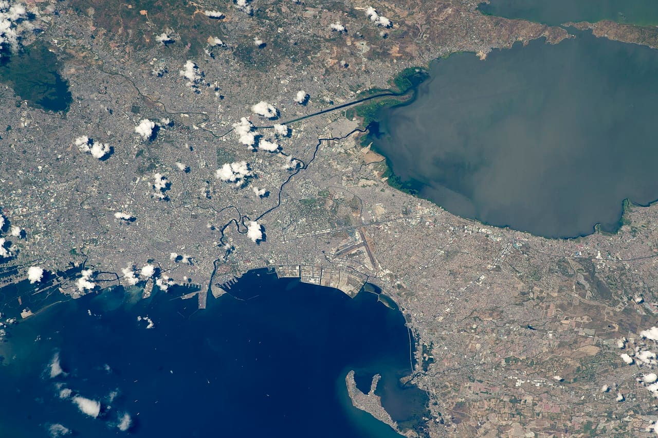
While orbiting over the South China Sea, an astronaut aboard the International Space Station (ISS) took this oblique photograph of the blocky red and gray urban pattern of Manila and surrounding cities. Manila is sandwiched between the salt water of Manila Bay—with its scatter of anchored ships—and Laguna de Bay. The great docks at the port can be seen jutting into Manila Bay (image center left), while the heart of the city lies immediately inland of the port. A forested nature reserve with a lake is located within one of the mountainous areas surrounding the metro zone (top left). The combined population of Manila and neighboring Quezon City is 4.7 million people. Manila itself has one of the highest population densities in the world, with 42,857 people per square kilometer. The metropolitan area is the political and economic hub of the Philippines, and its international trade connections are so widespread the Globalization and World Cities Research Network classed Manila as a global city. Manila’s history has always been connected to trade. Arriving from Mexico, the conquistadors founded Manila in 1571, and soon the city became the Far East anchor of the Acapulco-Manila Galleon trade route connecting Spanish America with Asia. This represents one of the earliest examples of globalization. The dark lines of several waterways are prominent amidst the gray cityscape. The Pasig River winds through the middle of the city. The straight line of the Manggahan Floodway is a flood-control channel engineered to divert water from the Marikina River away from the city center and into Laguna de Bay. Engineering works along the floodway also control tidal saltwater flow into Laguna de Bay. Astronaut photograph ISS047-E-99713 was acquired on May 6, 2016, with a Nikon D4 digital camera using a 400 millimeter lens, and is provided by the ISS Crew Earth Observations Facility and the Earth Science and Remote Sensing Unit, Johnson Space Center. The image was taken by a member of the Expedition 47 crew. The image has been cropped and enhanced to improve contrast, and lens artifacts have been removed. The International Space Station Program supports the laboratory as part of the ISS National Lab to help astronauts take pictures of Earth that will be of the greatest value to scientists and the public, and to make those images freely available on the Internet. Additional images taken by astronauts and cosmonauts can be viewed at the NASA/JSC Gateway to Astronaut Photography of Earth. Caption by M. Justin Wilkinson, Texas State University, Jacobs Contract at NASA-JSC.

有8个地点可乘机票前往Paranaque City,分布在1个国家,由0家运营方经营。最便宜的抵达票价为€107.52。出发地最近88公里,最远964公里,中位数为458公里。

2026年10月15日定价一名乘客,全部费用已含

票价

抵达Paranaque City

未来三周内前往Paranaque City的最低票价与最快行程。
线路起价最快距离
达沃市到Paranaque City机票€107.5213小时13分964公里
Cebu City到Paranaque City机票558公里
奥隆阿波到Paranaque City机票88公里
Tuguegarao到Paranaque City机票357公里
  • 8可以出发的地方
  • 1国家
  • 0运营方

机票把您送到Paranaque City,但送不来一张床,我们也一样。

一间酒店客房

机票抵达的那一晚,在Paranaque City住哪里

按离Asia World station的距离排序,哪些步行十分钟能到、哪些不能,一目了然。

合作伙伴链接。订单完成时我们会拿到佣金,这不会改变您付的价钱。

客源半径

人们从多远的地方赶来

自我们销售的每个出发地起算的直线距离,而不是线路的实际里程。
距离线路占比其中最近的
200 公里以内225%Olongapo,88 公里
200 至 600 公里450%Tuguegarao,357 公里
600 至 1,500 公里225%Davao,964 公里
出发国

可以从哪些国家出发抵达

按线路计数,因此一个在该干线上有多座城市的国家,是每条线路计一次,而不是每座城市计一次。
国家线路占比
菲律宾8100%
出发

从Paranaque City出发

关于飞往Paranaque City的机票的常见问题

可以从哪些地方乘机票前往Paranaque City?

在我们的网络上,有8个地点可乘机票前往Paranaque City,分布在1个国家。最近的直线距离88公里,最远964公里。

去Paranaque City的机票要多少钱?

前往Paranaque City的机票最低票价为一名乘客€107.52,覆盖未来三周内的8个出发地。出发地直线距离中位数为458公里,这个票价应当对照这个距离来看。

去Paranaque City的机票要多久?

前往Paranaque City最快的机票行程门到门为13小时13分。出发地直线距离中位数为458公里,因此这份列表上的多数行程都比这里给出的最快值长得多。

这些数字从哪里来

本页的地点、坐标、运营方、哪家运营方服务哪对地点,以及所有距离,都是真实的,来自开放数据。凡是有正式登记时刻表的线路,发车时间也是真实的;轮渡票价则是各家公司自己公布的价格。

凡是我们持有实时报价的地方,价格来自供应商。其余地方,我们给出的是按真实距离、真实运营方,以及随提前天数、星期几和季节变化的票价曲线算出的参考价格。这些标注为估算票价,无法预订。

完整说明见 客源半径, 票价, 门到门

前往Paranaque City的其他方式

用 Ori 规划

Ori,行程规划助手

可以这样问它